
Florida Public Radio Emergency Network (FPREN) Storm Center | By Megan Borowski
Pasco Schools are closed Tuesday. St. Pete has issued a flooding alert, see below.

Just a few days after a cold front brought heavy rain to the Sunshine state and a few strong thunderstorms, including one that spawned a tornado over Ft. Lauderdale, another storm system is taking aim at Florida. And this one is forecasted to be much stronger than its predecessor. Strong straight-line winds, large hail, and a few tornadoes, some of which could be strong, are all possible as next storm system impacts Florida Monday night and throughout the day Tuesday.
On Monday morning, an intense mid and upper-level disturbance was positioned over the Southern Plains. Winds in the mid and upper levels were quite strong, and a warm and humid airmass from the Gulf of Mexico was being drawn northward. At the same time, surface low pressure was deepening over the Southern Plains. Widespread rain and thunderstorm activity was already being produced by the system over eastern Colorado and New Mexico, and throughout Kansas, Oklahoma, and Texas.
Through the day Monday, the surface low is forecasted to intensify, aided by the strong disturbance in the mid and upper levels. The core of the system should track through the Plains toward the Midwest, dragging both a warm front and a cold front through the Central Gulf Coast and Southeast. The passage of both these fronts will produce the threat for multiple rounds of severe weather across parts of Florida Monday night and Tuesday.
Round I: Warm front passage
As of the latest model guidance, a strong warm front should lift from south to north through the length of the state of Florida overnight Monday into the pre-dawn hours Tuesday. Widespread light to moderate rain rates are expected from the Panhandle to North Florida during this time, however the environment will be able to support a few rotating thunderstorms. As such, there is an isolated risk for hail, damaging straight-line winds, and stray tornadoes overnight Monday into early Tuesday over the Panhandle and North Florida as the warm front tracks northward.
Round II: Cold front and Potentially Dangerous Squall Line

Forecasters at the Storm Prediction Center and local National Weather Service offices are more concerned with hazards posed by and directly ahead of the second round of storms. After the warm front lifts northward, a cold front should barrel through the state of Florida from west to east. Directly ahead of this boundary, winds are expected to stiffen. Sustained winds of 25-35 mph are likely, and frequent gusts between 35 and 45 mph are possible. Wind alerts have already been issued for the Panhandle and North Florida, valid for most of the day Tuesday. These conditions should immediately precede a squall line of dangerous thunderstorms directly along the leading edge of the cold front.

1 of 2

2 of 2
As of observational and forecast data from Monday morning, the primary hazard from these squall-line thunderstorms will be straight-line wind gusts between 60 and 80 mph. These conditions could down tree limbs, trees, and power lines, and any unsecured objects may be lofted into the air. Scattered power outages are possible. In addition, a few strong tornadoes and isolated instances of large hail are not out of the realm of possibility.
The latest time of arrival forecasts are as follows:
Tampa: 6 PM – 9 PM EST for squall line
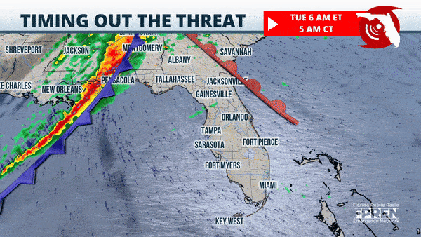
Pensacola: 10 PM-1 AM CST for warm front storms, 4 AM – 6 AM CST for squall line
Panama City: 11 PM – 1 AM CST for warm front storms, 5 AM – 7 AM for squall line
Tallahassee: 3 AM – 7 AM EST for warm front storms, 9 AM to 12 PM EST for squall line
Jacksonville: 2 PM – 5 PM EST for squall line
Gainesville: 2 PM – 5 PM EST for squall line
Tampa: 6 PM – 9 PM EST for squall line
Orlando: 6 PM – 9 PM EST for squall line
Melbourne: 6 PM – 9 PM EST for squall line
Fort Myers: 9 PM to 1 AM Wednesday for squall line
Fort Pierce: 9 PM to 1 AM Wednesday for squall line
Miami: 11 PM to 5 AM Wednesday for squall line
Readers are encouraged to continue checking the forecast, as details may change. In addition, we encourage everyone to check to insure they have multiple ways of receiving weather alerts and are prepared to quickly seek shelter if a severe thunderstorm or tornado threatens their area.
City of St. Petersburg issues a flooding alert
Potential Storm Impacts and Coastal Flooding Coming to St. Pete’s Low Lying Areas What You Need to Know For This Week’s Storm
St. Petersburg, FL (January 8, 2024) – St. Pete’s low-lying areas may experience approximately 2-3 feet of coastal flooding on Tuesday evening, Jan. 9. Due to severe weather systems, highest storm surge will be from Tuesday evening around 6 p.m. until midnight. St. Pete neighborhoods impacted may be Shore Acres, Snell Isle, and Riviera Bay.
What to expect:
- Dangerous marine conditions beginning tonight, Jan. 8.
- Possible coastal flooding, beach erosion and scattered severe storms possible.
- Prepare for potential flooding from storm tides in low-lying neighborhoods prone to flooding.
- Impacted neighborhoods may be closed to all traffic Tuesday afternoon into Wednesday IF street flooding becomes a safety issue.
- Hazardous marine conditions.
What to do to prepare
- Sign up for Alert St. Pete – www.stpete.org/alertstpete
- Vehicles: If flooding has been an issue before, move your car to higher ground.
- Waterfront Property: Tie down boats at docks and marinas.
- Sandbags: Sandbags are available to the public until 6 p.m. today, Monday, Jan. 8: Stormwater Pavement Traffic Operations Building, 1744 9th Ave N., Mangrove Bay Golf Course 875 62nd Ave. NE, Lake Maggiore Shelter Area 3601 Dr. MLK St. S.
How City Teams Are Preparing for the Storm:
- City leaders and Administrators briefing throughout the day to prepare for the storm and coordinate any needed emergency response.
- Storm drains cleared of debris and street sweepers activated.
- Sandbags delivered to homes that were flooded last December.
- Sandbags distribution was extended over the weekend and are available to the public until 6 p.m. today, Monday, Jan. 8: Stormwater Pavement Traffic Operations Building, 1744 9th Ave N., Mangrove Bay Golf Course 875 62nd Ave. NE, Lake Maggiore Shelter Area 3601 Dr. MLK St. S.
If residents experience flooding, please visit www.stpete.org/flooding for resources and information and what to do next.


